Where To Walk In New Zealand
If you like a good walk, then you will be in heaven here in New Zealand as there are just so many trails and bushwalks on offer throughout the country. From quick strolls to day hikes to multi-day treks, New Zealand has it all and it's definitely worth pulling on your hiking boots while you are here. In fact, I would go as far as to say that you haven't properly experienced the Kiwi countryside until you have gone tramping (the Kiwi term for hiking) through it.
The Essentials
Generally, hiking in New Zealand is pretty straightforward - many of the trails are excellently maintained by the Department of Conservation, are well signposted and are usually fairly popular. However there are a few points to be aware of if you intend to go off exploring. Unlike in countries such as Australia where it seems like everything is out to get you, there is no wildlife in the New Zealand countryside that is going to kill you, no venomous snakes or insects and its only harmful spider is incredibly rare. In fact, the forests over here are usually eerily quiet and empty, with birds and the odd rabbit being the only wildlife you are likely to come across. However, the Kiwi backcountry can still be a dangerous place if you don't respect it. As the country is so sparsely populated, places can become very remote very quickly and there can be a distinct lack of phone signal. The usual precautions of making sure someone knows where you're going and taking enough water and food with you are simple, but important. The terrain can be very rough and challenging and the unpredictable weather can change rapidly, especially in mountainous regions, so be prepared. As long as you take a little bit of common sense with you while hiking though, you should be absolutely fine, so get out there and enjoy this beautiful country!
Wellington Walks
So, I'll start close to home - there are loads of walking opportunities in and around Wellington that are not to be missed. Mount Victoria, a prominent feature of the city skyline, has several tracks up to its summit and is a decent little walk, easily accessible from the city centre. Once you've reached the top, enjoy the views of the city and the harbour from the lookout before making your way back into town. Mount Victoria also forms the first part of the Southern Walkway, an 11k trail out to Island Bay. The trail can be walked in around 4 to 5 hours and I recently made a full day of it by taking the Southern Walkway out and returning along the City to Sea Walkway after a quick ice cream stop in Island Bay. Mainly crossing town belt land, this path snakes its way over the hills to the south coast, however if you're going to do this walk then make sure you've checked out the route beforehand as the trail is (uncharacteristically for New Zealand) poorly signposted. A little further from the city centre, although still easily accessibly by bus, is Otari-Wilton's Bush Reserve. This forest park has several short paths criss-crossing through it and also provides access to the Skyline Walkway, a 12k track running from Johnsonville to Karori.
Tongariro Alpine Crossing
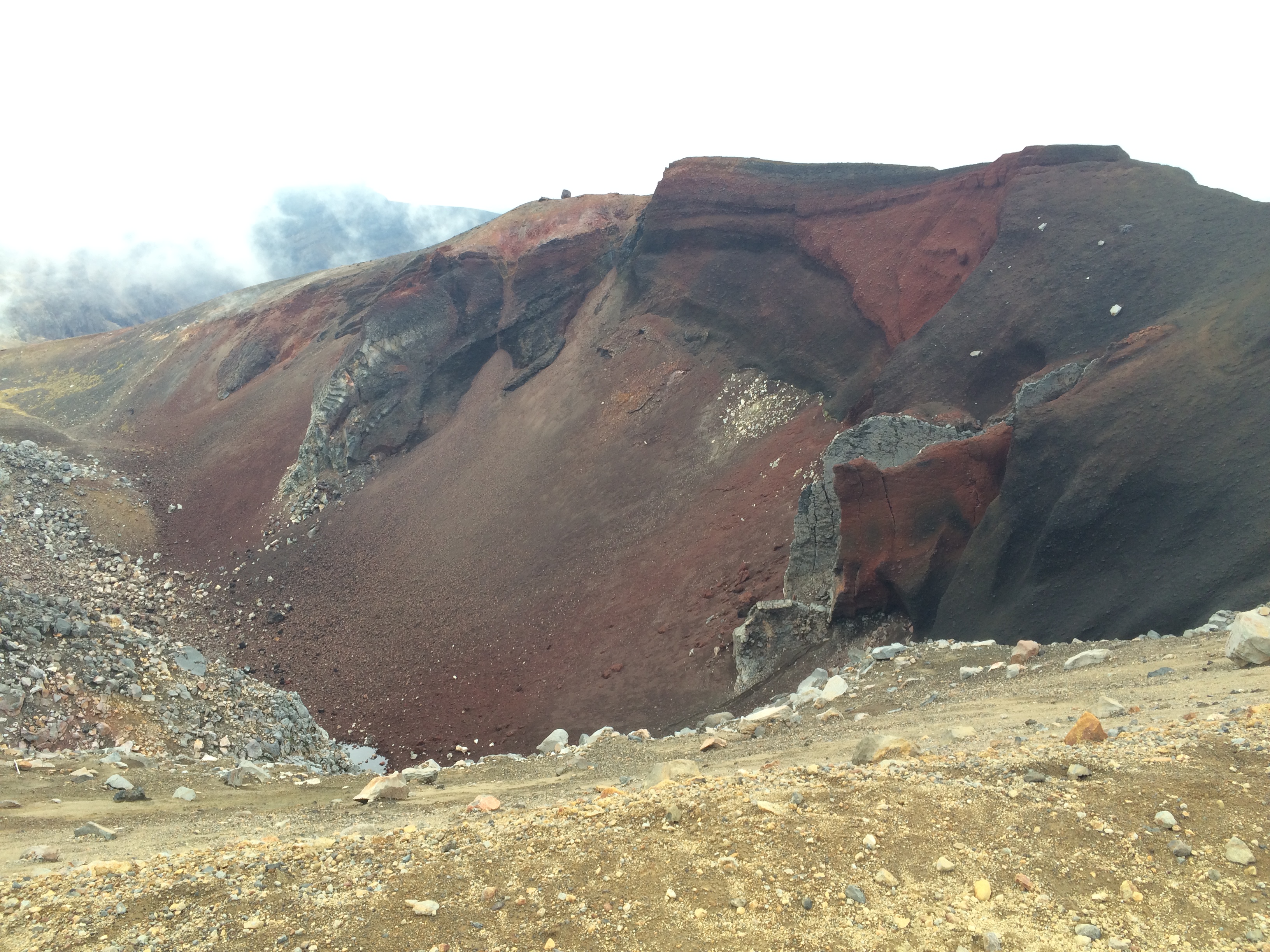
The Tongariro Alpine Crossing is widely regarded as one the best day walks in New Zealand, and with good reason, at 19.4km through tough alpine and volcanic terrain, this isn't an easy stroll but nevertheless, this doesn't stop thousands of people completing it each year. Located in the central North Island, the track starts at Mangatepopo car-park near the small town of National Park and at first winds its way fairly gently up through the valley, a nice little warm-up for the climbs ahead. One of the hardest bits of the walk is the Devil's Staircase, a steep, rocky section climbing sharply from 1400m to 1600m above sea level. Take it easy, as you don't want to exhaust yourself this early on in the day, luckily when I was there the path was busy so we had no option but to take it slowly. The top of the Staircase opens out into a large crater between Mount Tongariro and Mount Ngauruhoe, a strange landscape conjuring up images of Mars or the Moon. From here, there is the option of adding either of these summits onto your walk, with Tongariro being the easier of the two. As we were making good time, we went for it as it only added around an hour onto our walk. Although not a particularly steep climb, it was treacherous in places, passing along a loose scree ridge and involved a bit of scrambling to reach the very top, standing at 1967m.
Although it was very cloudy, we did manage to catch a quick glimpse of the craters below us. Once back on the main trail, make time to take in the red crater, with its amazing brightly-coloured rocks before scrambling down the slope to the Emerald Lakes, several pools of brilliantly blue and green water caused by volcanic minerals. The trail progresses through an actively volcanic landscape, and signs advise you not to hang around too long due to the very real risk of eruptions. As the worst of the climbs were over by this point, we decided to take it at a bit of a jog, despite the odd looks from many other walkers! By the time we started on the downhill forested section, we were still running and had got a little carried away, trying to pass everyone we saw. We completed the walk in good time, under the suggested seven hours, so as highly competitive people, we were happy. If you're visiting New Zealand, this walk should definitely be included in your itinerary, it is high up there among the best things I have done during my travels.

Ben Lomond
A challenging but do-able day walk to the summit of Ben Lomond, the 1748m-tall mountain looming over Queenstown is an excellent outdoor activity here in the country's adrenaline capital. For a further account of it, check out my article dedicated to Queenstown here.
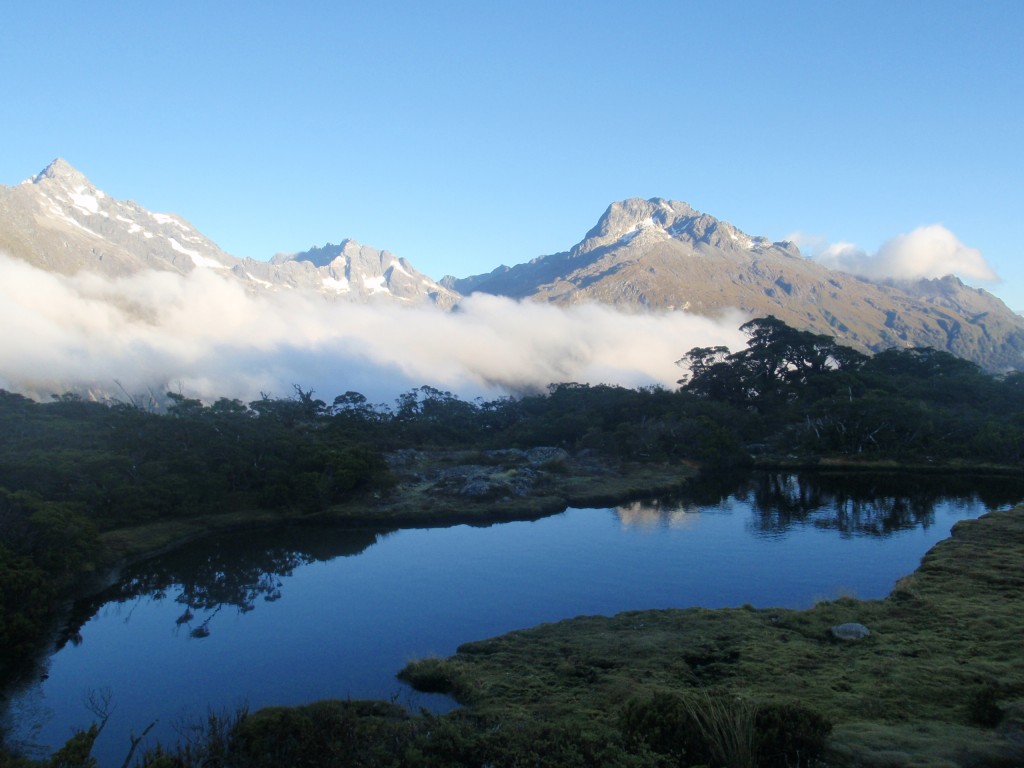
Key Summit
Part of the South Island's Routeburn Track, one of New Zealand's nine Great Walks, the hike to Key Summit is not to be missed if visiting Fiordland. I did this walk while travelling on the Stray bus in 2015 as they include it as part of their Deep South route. Setting off before dawn one morning from Gunn's Camp, a lovely little campsite in the middle of nowhere, we walked for around an hour and a half up to the summit. The track is well-formed, climbing up through the forested mountain foothills and is generally pretty easy-going underfoot, if you factor out the steep gradient. Reaching the top, a marshy plateau sitting at an altitude of 919m, just as the sun was rising made for incredible views of the surrounding mountains and lakes jutting out from among the clouds. I would definitely recommend this walk, if you're not keen on the climb, just remember the views at the top will make it worthwhile!
Lighthouse Climbs and Waterfall Walks
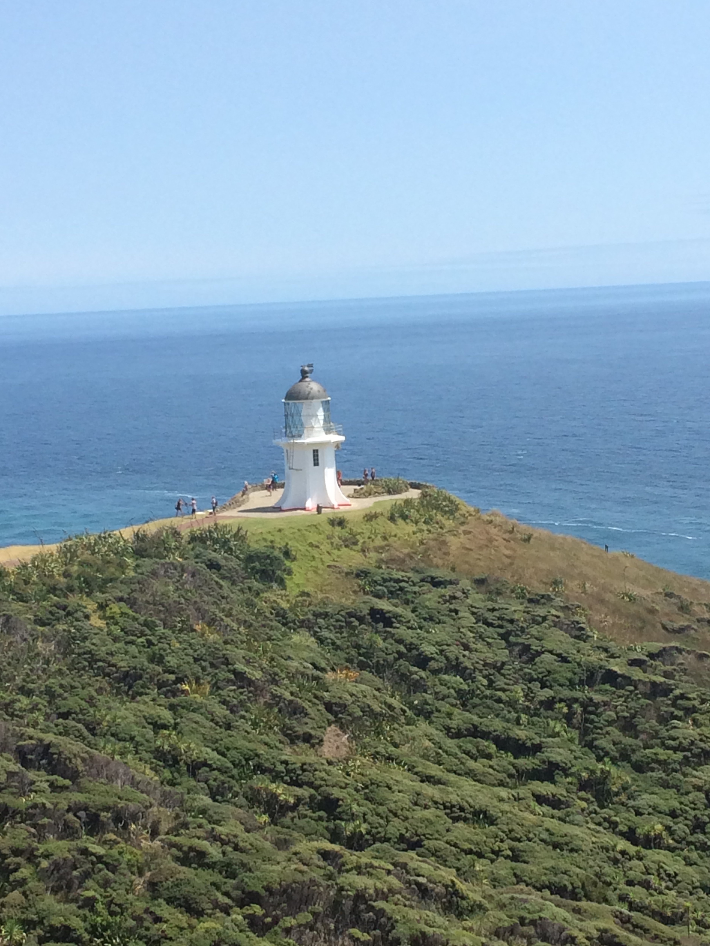
I have lost count of how many lighthouses and waterfalls I have walked to during the last year I've spent in New Zealand, but here are some of my favourites. The lighthouse at Cape Reinga sits at the northern tip of the North Island and marks one end of State Highway 1, which runs the length of the country to finish at Bluff, the southern tip of the South Island. This lovely little walk was first on my list of visited lighthouses and also one of the first things I did on my travels here, which may be why it is one of my favourites! It is also the only lighthouse I have visited here that you don't have to climb up hundreds of steps to reach. Make sure to take a photo of the yellow signpost next to the lighthouse, which matches the one down in Bluff.
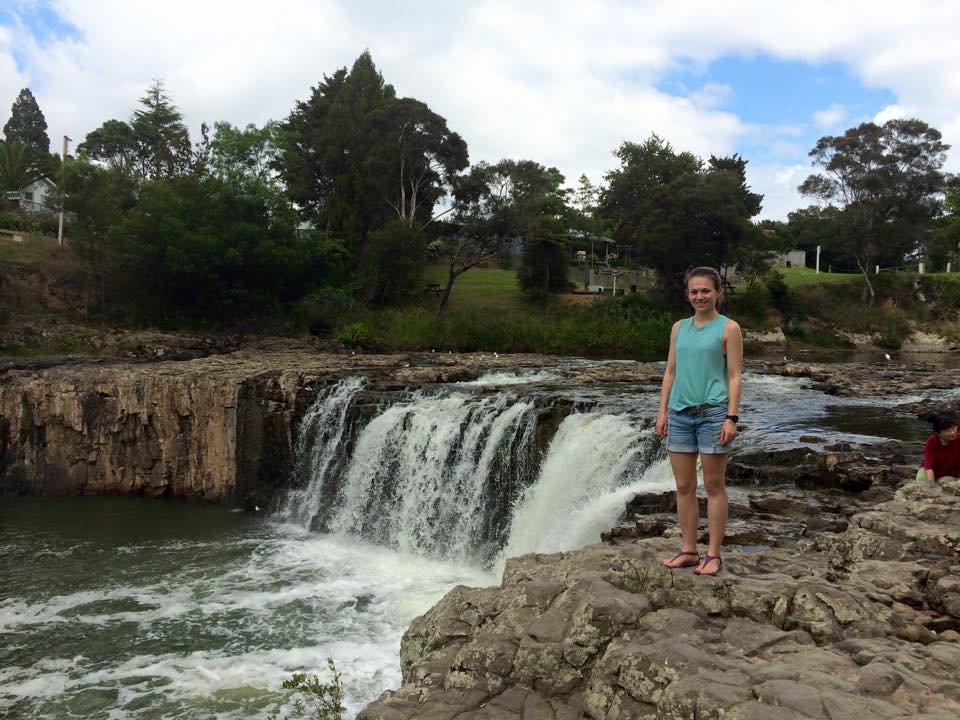
Also up at this end of the country, is one of my favourite waterfall walks, the 6km track to Haruru Falls from Waitangi. The trail largely passes through forests, along the banks of the Waitangi River but one section includes a boardwalk through the mangrove swamp, which is pretty cool. The waterfall itself is fairly impressive and worth the walk, when I was there, we could walk out onto the rocks very close to the rushing water. The walk back to the town of Paihia however, was less than scenic, following a busy road with no footpath. We didn't realise this was the way back, and I would recommend looking into a taxi or bus to take you back to avoid this bit as it is not particularly pretty or safe.
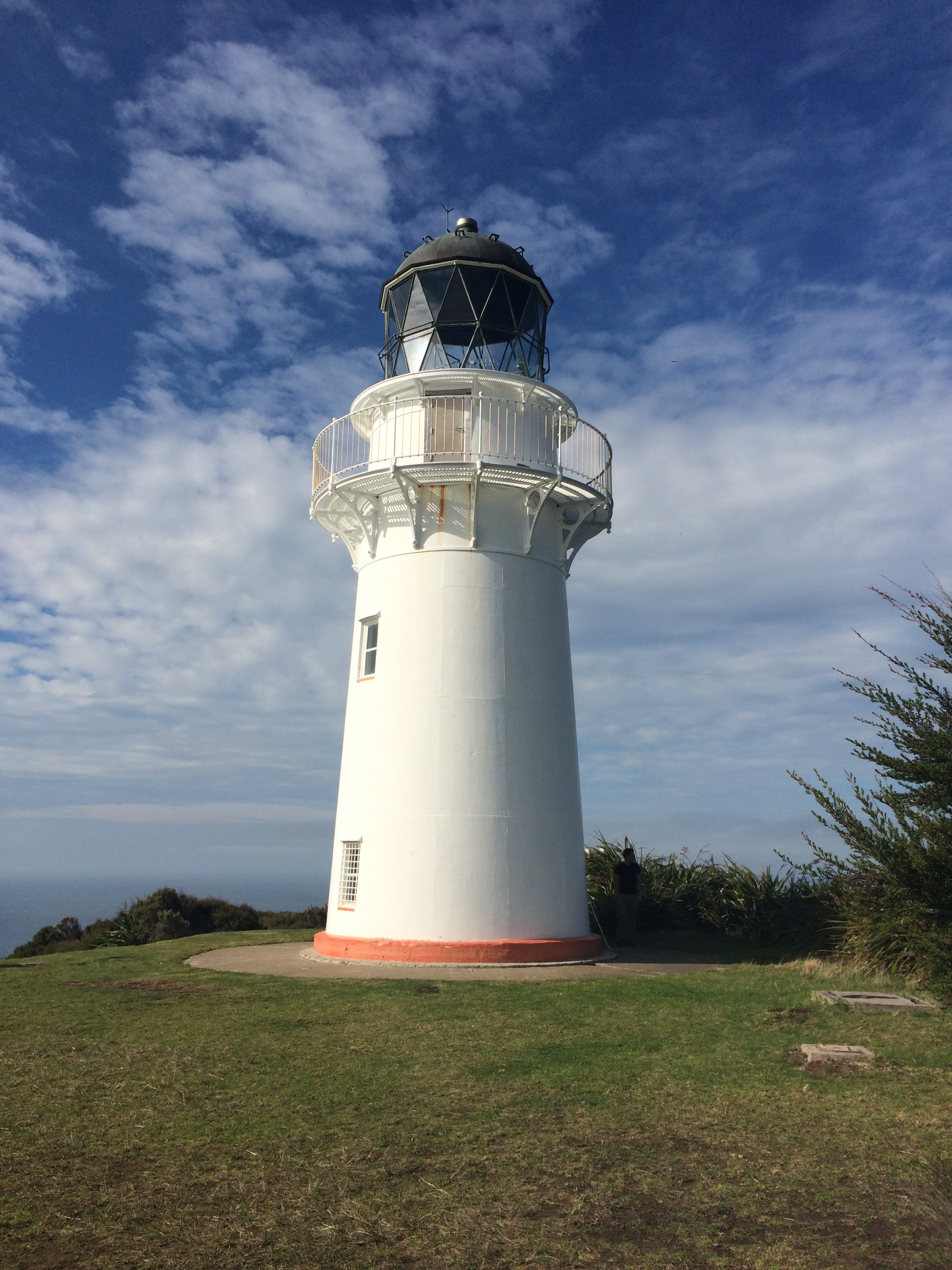
Other lighthouses I have visited include the East Cape lighthouse and the one at Cape Palliser, a couple of hours drive outside Wellington. The East Cape lighthouse is the eastern-most lighthouse in New Zealand, if you set sail from here, the next bit of land you reach would be Chile. If you're feeling energetic, you can walk up to the lighthouse, via some 700 steps; the view at the top over the ocean and the valley is worth the climb. The Cape Palliser lighthouse has a slightly less daunting 250 steps up the cliffside to reach it. With views down the rugged beaches of the North Island's south coast, home to several sealion colonies, this area is a good road-trip destination from the capital. Both of these lighthouses are still in use today, although are both now controlled from Wellington.
Hooker Valley Track
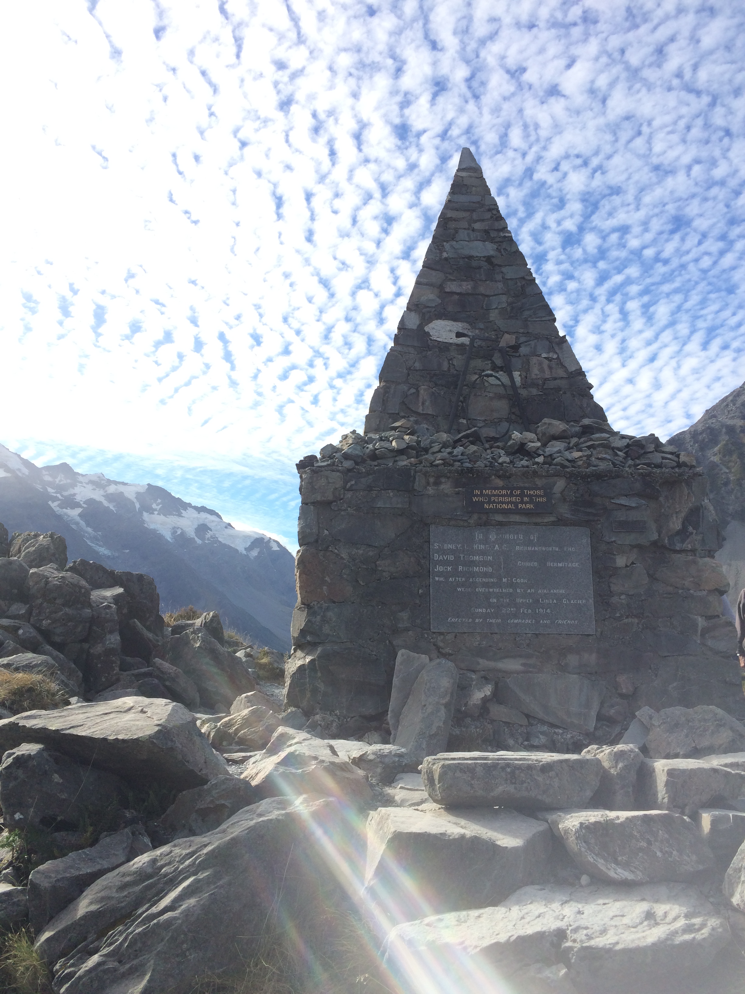
A relatively easy walk over well-formed paths and boardwalks, the Hooker Valley Track takes you through some incredible, dramatic scenery to the lake at the base of Aoraki/Mount Cook. From the car park at the start of the trail, the walk takes around an hour and a half each way, but be prepared to want to hang around a while to gawp at the amazing landscapes. Along the way, you will come across the Alpine Memorial, views of the Mueller Glacier and you also get to cross several swing bridges. At the end of the trail, you will be rewarded for your efforts with the view of Aoraki/Mt Cook, New Zealand's tallest mountain, as well as its reflection in the glacial lake in front of you. The photos I took here are among my favourite in my entire New Zealand album!
Exploring the Kiwi countryside on foot is one of the best ways to really experience the incredible landscapes and scenery this country has to offer, whether you are after adventurous mountain peaks or strolls through the forests, you'll find it all here in New Zealand.